Sunday, August 28, 2011

Margaretville flood

Hurricane Irene: Storm Warnings : The New Yorker

Jim Cantore, of the Weather Channel, in Battery Park.
Photograph: The Weather Channel/Getty Images.
Weather channel syndrome - its meaning for our time.
Global warnings: a taste of things to come? - GWC

by Adam Gopnik - the New Yorker
"We happened to be seeing out the summer on Cape Cod last week, thinking we’d come home Sunday, when news that the hurricane was on its way first got around. We blessedly don’t have the Internet or a television in the house we rent up there; you get your news by biking down to the local grocery store for the paper or just by hearing what’s up on the beach—or, when the satellite decides to pass over in a good mood, from the occasional snatch of info you can grab from your iPhone. Talking round with friends, it sounded like Sunday would be mighty rainy and windy and that it would be prudent to come home sooner. Since traffic is always horrific coming home from the Cape on Saturday, we decided to drive back Friday night."

'via Blog this'

Eagle Island light

Islands are places of dreams, where, we imagine, we are free to build lives of our own choice, free to be alone, and free to leave to join the rest of the world. Eagle Island in the east Penobscot Bay is a place that elicits such dreams.

Pescadotes: Herreshoff New York 30


The New York 30 - designed as a club boat for the New York Yacht Club (which has a sidewalk in New York and a dock in Newport) is one of Nat Herreshoff's masterpieces. Nice job here by Joe Warren to capture boat and summer sky.  In the old style `30' refers to waterline length, not length overall.
Pescadotes: herreshoff ny 30

Irene-damaged wharf - City Island Yacht Club

Francine Alheid's flickr photostream is HERE

We built a Lumber Yard Skiff!

At the WoodenBoat School, Brooklin, Maine, August 22-26, 2011 we (Dave, Casey, Walter Baron  and me) built a 16 foot Lumber Yard Skiff!
Walter is the designer and boat builder.  See his work at Old Wharf Dory Co.  My slide show is embedded below.
Casey's excellent slides are HERE


And here's a video of the LYSS making its way up the rapids below a dam:

Saturday, August 27, 2011

Issuma: 105' West -- Cambridge Bay, Nunavut

Go due North from Boulder Colorado for a thousand miles.  You'll find Issuma there.  But three cruise ships got there first to Cambridge Bay, the Victoria Islands, Nunavut, Canada.
As Yann, the boat's builder and first captain commented "What do you have to do to get away?


Friday, August 19, 2011

Issuma: heading west!


The + marks Bellot Strait.
The big island to the east is Baffin.
Below it is Labrador.
Issuma is so far north that the compass needle points down.  This is looking like the beginning of a northwest passage, NOT a circumnavigation of Baffin Island.  Bellot Strait - which Issuma just traversed westbound - is the northernmost point on the North American continent.  Perhaps wintering at an arctic port is the plan.  The photo is of the Bellot Strait which Richard describes below.  Go directly to Issuma to learn how they did on their passage through the strait.
"Bellot Strait is an 18 mile long passage between Prince Regent Inlet and Peel Sound. It was named after Lieutenant Bellot of the French Navy who came across it in 1852. It has a difficult reputation due to its fast tidal currents and a rock that is awash (so hard to see) near the eastern end of it. While there was no ice when we passed, Bellot Strait has a reputation for quickly jamming with ice. The Sailing Directions note: "The tidal streams run with great strength through Bellot Strait...In the vicinity of Magpie Rock, the currents are highly variable; localised 7-8 knot westerly currents have been reported on the north side of the channel at the same time that equally strong easterly currents were flowing on the south side. Mariners should exercise extreme caution in this area."

Wednesday, August 17, 2011

Iceberg in Labrador Sea - from a satellite

This photo by NASA astronaut Neil Garan is of an iceberg in the Labrador Sea - where Richard and Issuma have been wandering.

Perseid meteor seen from space station

NASA astronaut's pictures from space show a meteor entering the atmosphere during the Perseid meteor showers.

Tuesday, August 16, 2011

Issuma: circumnavigating Baffin Island

Issuma reports its current position as the Bellot Strait - the picture here is of Devon Island - the largest uninhabited island on earth.  It is the site of the Mars on Earth project's research.  They think it is the most Mars-like place on earth and they have been up there with robots.
On one side of the Bellot Strait is Somerset island.  That is the second image.  I get nervous and dizzy just thinking about being that far north - and that remote. On Somerset island was the last outpost of the Hudson Bay Company - Fort Ross.

Yrvind talk about knots - YouTube

Sven Yrvind demonstrates the Secure knot - a kind of super bowline.
Yrvind talk about knots - YouTube

Septuagenarian Swede sets sail across Atlantic in tiny boat | News | Pbo

Sven Yrvind may be a madman, but he's not crazy. He has a great sailing resume.  His adventures have taken him across several oceans, often solo. His was the first yacht to land at the remote South Atlantic island Tristan da Cunha, and he set a record rounding Cape Horn on a 20-footer in winter. In 1980, under the name Sven Lundin, he was awarded the Royal Cruising Club medal for seamanship.
At an expected average boat speed of 2.5 knots Sven hopes Bris will reach Madeira in less than 30 days.
Read more about Sven and Bris on www.yrvind.com
Septuagenarian Swede sets sail across Atlantic in tiny boat | News | Pbo

Sunday, August 14, 2011

Arctic Ice Thinning 4 Times Faster Than Predicted by IPCC Models, Semi-Stunning M.I.T. Study Finds | ThinkProgress

Arctic Ice Thinning 4 Times Faster Than Predicted by IPCC Models, Semi-Stunning M.I.T. Study Finds | ThinkProgress

Issuma crosses Baffin Bay from Greenland

Issuma has crossed Baffin Bay and is now in Canadian waters NORTH! of Baffin Island at 74.0 North.  The graphic is a scanned copy of a weather fax ice chart, with Issuma's track superimposed.  They are on the latitude of the Northwest passage.  It's a straight shot to the Bering Sea!  They wouldn't.  They couldn't - not this late in the year.   We may have to wait for the next post - Richard's sat phone contract has expired and the telephone renewal link isn't working!

Saturday, August 13, 2011

A stroll through Wyeth's Giverny - NYTimes.com

The Farmhouse of Wyeth’s ‘Christina’s World’ - NYTimes.com: "To Wyeth the Olson farmstead was a little like the garden at Giverny was to Monet several decades earlier: an inexhaustible subject for his paintings."
I, of course, concur.  For a dozen years we have rented the hosue on Stones Point across Maple Juice Cove from the Olson House.  This is a nice piece to encourage visitors to come for the magic of mid-coast Maine, of Wyeth's - and my - garden at Giverny.  We're all channeling Monet. - GWC (all photos are mine)

Alvaro & Christina

Christina's world - the iconic image

Andrew's grave

Friday, August 12, 2011

SeaPaddleNYC 2011

SeaPaddlers on the ship canal near Baker Field
Caught without my camera as a fabulous parade of paddlers - most standing, many in kayaks made its way north with the flood tide above the GW Bridge on a beautiful late summer morning, heading into a soft northerly.  Maybe I should do it in my Walker Bay 8' rowboat?  26 miles round Manhattan.  The currents had better be right.  Organized by SeaPaddleNYC, the whole flotilla looked great - with well-marked escort boats.


Thursday, August 11, 2011

The most northerly point? 72.45 N - Issuma

In 1587, John Davis made his third and last voyage to Davis Strait and what is now called Baffin Bay. Davis named this 300m/1000' cliff Sanderson's Hope, after his main financial backer, William Sanderson of London. Davis wrote 'no ice towards the north but a great sea, free, large, very salt and blue, and of an unsearchable depth'. - Richard Hudson 8/10/11
Will Upernavik, Greenland, 72.45 N be the point where Richard too turns back?  I would spend some time in Upernavik, Greenland if I had the chance.  Nice little town.  Beautiful sunset light at 11:30 PM this time of year.  Long, dark winters, of course.


Tuesday, August 9, 2011

Monday, August 8, 2011

Stones Point

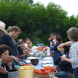
26 for dinner at our Stones Point reunion 2011! Click on the photo for the whole slide show!

Friday, August 5, 2011

Issuma: Greenland - showers and wi-fi

Somandshjemmet - showers & WiFi

Aasiaat, Greenland is on Baffin Bay,  north of the Labrador Sea.  It is north of Nuuk - the largest settlement.  Formerly Danish, it is now autonomous - with Danish support, as the name of Seaman's house shows.  In the second shot Issuma is against the bulkhead.  Aasiaat's tides are moderate - today's 2.3 meters is about as high as it gets.  (We had more than that today on the Muscongus  Bay.)  
Richard mentioned ice awhile back but not in the run across the Labrador Sea.  The Canadian Cost Guard advises about ice.
- GWC

Thursday, August 4, 2011

Issuma: Greenland at last

Richard Hudson and crew have arrived in Aasiat, Greenland.  this was Richard's fourth attempt in three years.      He tells the story HERE